After Georgia, our next state of cycling was South Carolina. We started on a great note – an off day! And Bob and Sadie drove down to spend the off day with me and have dinner with friends in Beaufort! In a state with Hilton Head, Beaufort and Charleston, what was not to like? We would soon see.
On our off day, Bob and I ate breakfast and then I cleaned my bike and took Sadie for a run. We changed out my Look pedals for SPDs and I added cleats to my mountain biking shoes. (Of course, I made it hard by first installing the cleats upside down and wondering why I couldn’t clip into my pedals. Duh!) This change allows me to walk comfortably in bike shoes while on the tour. We also put on my new “trunk rack”, which holds essentials I want with me, rather waiting to arrive at a SAG stop. (Think things like a rain jacket if rain is likely – 10 miles is a long way in the rain with no jacket. Stay tuned for a separate post about the things I am learning about bike touring that differ from our regular weekend rides!)
Finally, we headed into Beaufort to wander around and have dinner with long-time friends Charlie and Cathy Johnson. It was a great day that ended too soon!
Cycling Point South to Moncks Corner (81 miles planned, 84 miles actual)
Sadly, the next morning, it was time to tell Bob and Sadie goodbye and ride our longest ride of the trip. We had a beautiful ride, mostly on two lane, rural roads. The big city along the way was Walterboro. It was here that we missed a turn and added about three miles to our trip. Beautiful city, lots of history. We went through Cottageville and Summerville on our route into Moncks Corner, which is about an hour drive from Charleston. There was really no place to stop for lunch, so we enjoyed the scenery and avoided major roads for most of the trip.
But, the major roads we traveled on were nail biters. We experienced lots of traffic and trucks, and par for the course in South Carolina, no shoulder, huge rumble strips and a few rednecks who thought it fun to buzz white chicks on bikes.
Despite the rest day, 84 miles was tough and I was delighted to be at the hotel!
Monck’s Corner to Georgetown (69 miles planned, 73 miles actual)
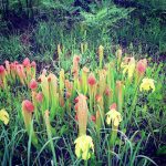
This route was a mixture of busy, two lane roads and winding country roads with little or no traffic. And for a couple of segments, some bone jarringly bumpy bad roads. We passed through the Francis Marion National Forest and lovely forests. We spotted some pitcher plants and wild, yellow iris along the way.
- Pitcher Plants and Wild Iris in the Francis Marion National Forest
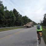
- Riding with logging trucks. From CCT Log (Marilyn from New Zealand)
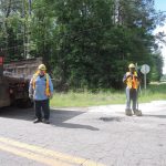
- The road crew. From CCT Log (Marilyn from New Zealand)
On one of the bumpy, quiet roads, we encountered a crew working on potholes. More than one of us mentioned that the road was FAR beyond the point that pothole repair would “fix” this road.
We got plenty of questions from the locals – “how far are your riding?” Most were surprised that we were riding to Georgetown, much less on to Maine! Everyone was friendly and helpful.
One stretch took us on Old Santee River Road, along old plantations and scenic streams. Peaceful and beautiful.
We decided to hold off for lunch until we reached Georgetown, which is a historic port city, third oldest city in South Carolina. The stretch had more bone-jarring roads, before merging onto a four lane highway and a 6% grade bridge over the river.
We were delighted to see historic Georgetown and stop for lunch. I loved having some iced tea! Again, people in town were fascinated with our journey and many stopped and asked about our trip. We took a tour of the town and checked out the historic homes, then on to the hotel.
At the hotel, the discussion turned to weather, the potential tropical depression. I crossed my fingers and got out the rain gear.
Georgetown to Conway (52 miles planned, 39 miles actual)
OMG, what a day! We started in a light drizzle around 7:30 am on busy roads with morning traffic. At about mile 3, we veered off the busy road for a couple of less stressful miles, before rejoining SR 701. The route map called for 5.3 miles on this busy two lane before our next turn onto more peaceful roads. With the increasingly heavy rain, it was almost impossible to read my garmin, so I counted down each “ding” of the garmin as a mile passed. At the fifth mile, I thought – start looking for the blinking yellow light to make the turn off this busy road. Within 2/10ths of a mile, the SAG car passed to tell us the route map was wrong, and we had missed the turn. Three miles back! So our Hobson’s choice was to turnaround, ride three miles in even heavier traffic and add six miles to the route, or continue on SR 701 and cut off 10 miles. In the rain, the choice seemed easy – less miles!
At that point, we were about 26 miles to the hotel. So I started counting down – 1 mile done, 25 to go. What we encountered:
- Lakes in the road,
- no shoulder,
- huge rumble strips along the side of the road,
- bad road in the two feet closest to the rumble strips,
- Strong head winds,
- Low visability,
- Big rigs and logging trucks,
- Increasingly heavy traffic, and far less patience, as we approached the last 12 miles on SR 701 near Conway
EVERY TIME a big rig passed in the opposite direction, we are washed with water and swirling winds.
About 12 miles from town, we stopped at Pee Dee Grocery to just take a minute away from the death grip on the bike, the noise and the wind.
Funny enough, there was a young black guy and his friend stopped at the store on a motor scooter. He waved and I walked over to chat. I said, “I’m not sure who is worse off, you or me!” He started telling me about how harrowing the trip had been from his girl friend’s house to Pee Dee. “Those trucks and cars are moving so fast and they pass me with no room to spare. Scared me to death. So I pulled in here to find someone to ride behind me to my turn so I won’t get run over!”
He was right as the rain. The next 12 miles we experienced heavy traffic, more close passes, and great tension.
The route map called for a left hand turn that was easy to miss. So about a mile out, we pulled over and checked google maps for landmarks to help us find the turn. I counted it as good luck that my marker was a Spiritual Assembly of Baiha’is on the right side. My running friend Faraz is Baiha’i, and I felt the kind and gentle spirit of this faith looking after me. Once we turned at this marker, the roads were quiet and we started to relax for the last three miles to the hotel.
We were freezing once we stopped riding, and luckily, our rooms were ready early. We unloaded everyone’s luggage, threw some clothes in the wash, took a hot shower and went off to Subway for lunch, feeling pretty badass!
Conway SC to Shalotte NC (51 Miles)
The weather forecast was ominous when we went to bed before our last day in South Carolina. And, unfortunately, taking the phone out to check directions resulted in my phone getting wet. Again. So into the rice bag for the cure. But no easy fix -a kernel of rice wedged itself in the phone, making it impossible to charge, so a ride without a phone.
But the weather turned out to be fine, although the roads leaving Conway were again, extremely busy, two lane roads with no shoulder and rumble strips. And while there was no rain, there were plenty of headwinds. Around mile 38, we turned onto our last four lane South Carolina road. Instead of getting into the left lane, car after car gave us the minimum distance to pass. One last parting shot from South Carolina.
Our Impression of South Carolina
While the state is filled with history and beauty, the roads are not bike friendly. No shoulders, lots of traffic, lots of 18 wheelers and logging trucks, many poorly maintained roads and the occasional redneck to add to the mix. The amount of tension these issues caused will mar our recollection of South Carolina.
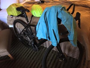
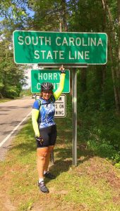
This shot expresses how many of us felt when we departed South Carolina:
Next up – you’ll read about riding in a tropical storm!


2 Comments
Wow – what a ride!!
It sure was! Thanks for following!